top of page


Nature in the city, The city in nature.
Urbanization has long eroded nature's boundaries, yet cities also create green spaces and parks—forms of "artificial nature."
This paradox highlights that humans and nature should not compete but coexist in cooperation and symbiosis.


Design Background
Main Ufer, a riverside area home to many birds, is a popular stop for passersby. However, 85% of it is used for parking, leaving little space for nature or leisure, frustrating many locals.
As a daily route for many, we aim to redesign it to better serve both people and nature.
We found records of this area's historical changes at the city museum.
Background of the research and
existing problems
After reviewing the archives of this area, we found that many records highlight issues with its uneven space distribution. There are also some failed projects that lacked a realistic approach.


We also analyzed the functions and their required structures to ensure that the redesigned space meets or even improves these needs.
Area Research 1
-
Low Parking Use: Out of 482 spaces, only 195 are used on average. The peak was 238 on Saturday during a flea market.
-
Flood Risk: The area has a history of flooding, so the dam must be preserved or even raised.

Area Research 2
There is a disconnect between design and use where plants meet pathways. Signs of "erosion" include trampled zones, waterlogged paths, rigid nature reserves, and broken fences from people climbing in.
Commuting → Routes
Recreation & Activities → Open spaces & facilities
Parking → Parking lots or multi-level parking
Flood Protection → Embankment
Flora & Fauna → Ecological community
Boat Docking → Embankment wall (river’s edge)
Fishing → Embankment wall
Grid System & Zoning
Using 10m-diameter circles, we created a flexible grid based on parking layout and space usage. The area is divided into three zones: parking, park, and plaza.


Main Zoning Areas

Size Comparison & Reference
Basic Grid Unit: 25 × 25 cm
Large Circle: 10m diameter (green circles in the diagram)
Detailed Zoning & Design
From planning to pavement, everything follows a unified grid system.
-
Grid Adaptation: Designed for pedestrians, strollers, bikes, cars, and parking, shaping roads and spaces accordingly.
-
Pavement Design: Custom tiles fit the grid, adapting in structure and material for smooth transitions between zones.


Tile Material & Structure
Material: EcoRock, a recyclable material developed by Serious Materials.
Structure: A dual-layer design with replaceable filling.
Functionality:
The interlocking top and bottom layers ensure strength and drainage.
Provides space for plant growth, creating a natural transition between human activity zones and green spaces.

The filling materials create a natural gradient, helping to differentiate and transition between zones.

Overall Render

The embankment features large steps, offering a perfect spot to enjoy nature and view the plaza and river.
Facilities in different zones provide more activity options while guiding movement to protect green spaces.
This design balances human use and nature, allowing for future growth and evolution.
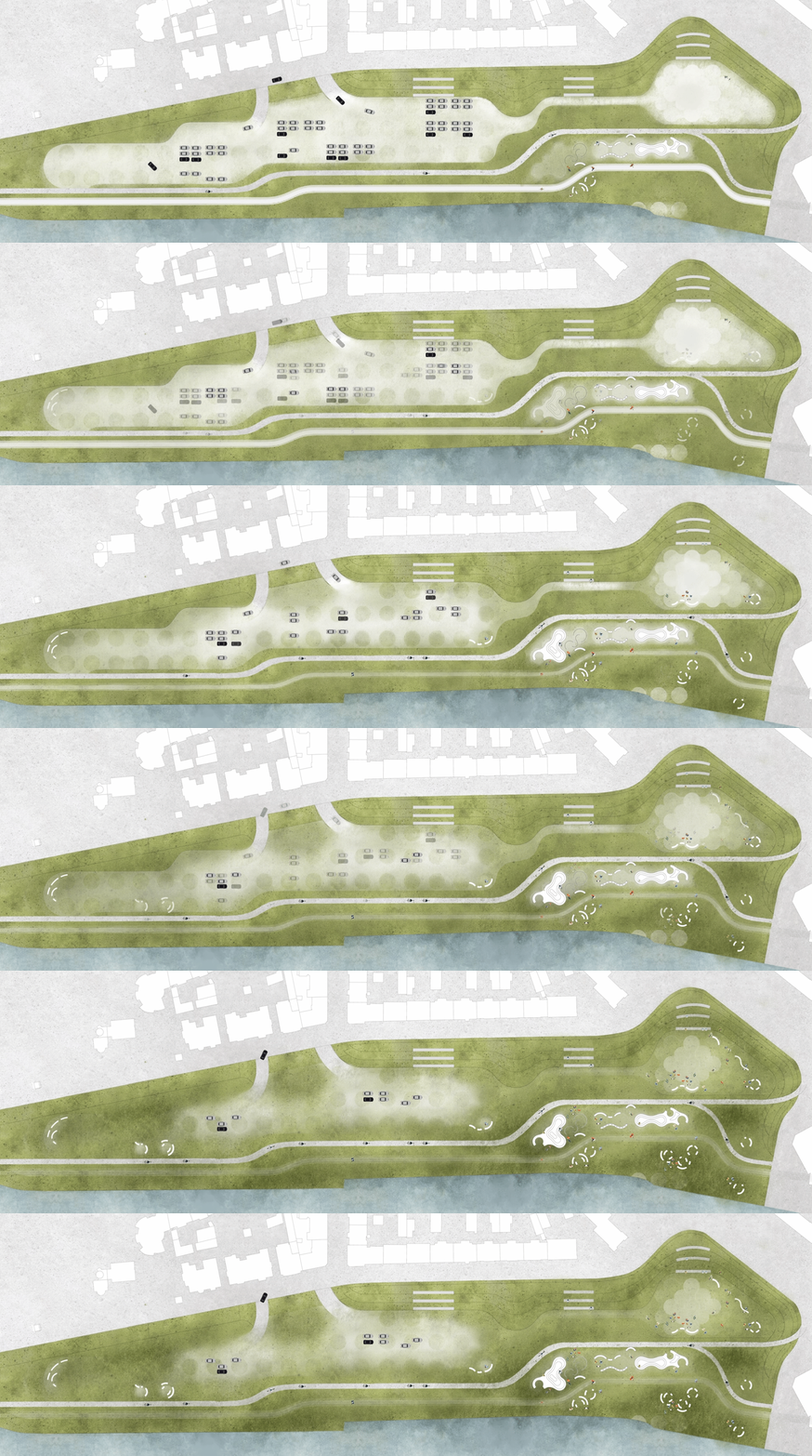
Park Evolution Over Time
Over the years, green spaces may expand while parking areas gradually disappear. The tiles serve as a foundation for continuous development.


Exhibition
2024.07 HfG Rundgang
Tile Model → 1:1, Foam
Park Model → 1:500, Cardboard
Tile Assembly Model → 1:10, 3D Printed

bottom of page